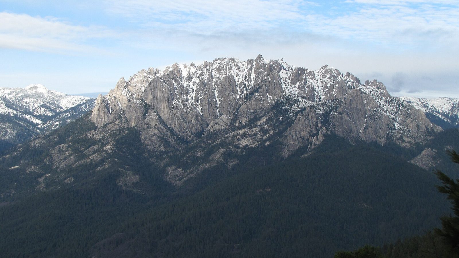
If you're in Mount Shasta this fall or winter and want a hike right off the freeway with big granite views, drive 14 miles south to Castle Crags State Park. It stays open for day use from 8am until sunset, and its short trails look straight at the crags and Mount Shasta. When snow does fall, the granite spires turn white and the big hike to Castle Dome becomes a real winter adventure.
Where is Castle Crags and how do you get there?
California State Parks puts Castle Crags 14 miles south of the City of Mount Shasta and 6 miles south of Dunsmuir, right off Interstate 5 at exit 724. The entrance station is at 20022 Castle Creek Road in Castella. There's a day-use fee per vehicle, paid at the park, and California State Parks day-use passes are accepted.
The crags themselves are granite spires about 6,000 feet tall. State Parks describes them as more than 170 million years old, rising along the northwestern edge of the park in the Castle Crags Wilderness.
What are the best easy trails at Castle Crags?
The park has 28 miles of trails, and several short ones work well on a cool fall afternoon or a clear winter day. All of these come from the park's own trail guide:
- Vista Point Trail. A 0.2-mile, ADA-accessible path from the Vista Point parking lot to a viewpoint looking at Castle Crags, Mount Shasta and Gray Rocks.
- Root Creek Trail. About 1.1 miles each way from the Vista Point area with only 60 feet of climbing, shaded, accessible, and ending at a creek that flows year-round.
- Indian Creek Nature Loop. A 1.1-mile loop near the main entrance that crosses Indian Creek twice on wood and stone bridges.
- River Trail. An easy 1.5 miles each way along the Sacramento River, popular with anglers. Watch for Pacific yew along the banks.
How hard is the hike to Castle Dome?
It's the park's signature hike, and State Parks rates it strenuous. The Crags Trail climbs about 2,200 feet in 2.7 miles each way to the base of Castle Dome. The first 1.5 miles are in dense forest. Just past that, a five-minute spur leads to Indian Springs, which flows out of the granite all year. Beyond the spring, the trail enters the Castle Crags Wilderness, managed by the U.S. Forest Service, and the final stretch is steep, rocky and has no shade.
The longer option is Bob's Hat Trail from near the park entrance, which reaches Castle Dome in about 3.6 miles each way with roughly 2,600 feet of climbing.
What is Castle Crags like in winter?
It changes with the weather. The park's info sheet says that during the winter and off-season the Upper and Lower Loops of the main campground, the Riverside campground and the pedestrian underpass are closed, and that in particularly severe weather the entire park may close. The underpass closure matters if you planned to reach the River Trail from the Riverside campground connector, so use the Riverside Road or Frontage Road access points instead.
After a storm, the Castle Dome route is a different hike. The California State Parks Foundation describes the snowshoe up to Castle Dome as strenuous, at about 5.6 miles round trip and over 2,200 feet of gain, with views of the spires, Mount Shasta and the surrounding Shasta-Trinity National Forest on a clear day. If you go up in snow, bring snowshoes or traction and poles, and turn around if it doesn't feel right. On a short winter day, the Vista Point and Root Creek trails are an easy way to see the crags with snow on them without committing to the climb.
State Parks recommends layers, since fall and winter here can be cool, and reminds hikers to tell someone where they're going, carry a charged phone, hike with a buddy and bring extra water, food, light and first aid. Parts of the park may not have reception.
Can you bring your dog to Castle Crags?
Mostly no. Dogs aren't allowed on the park's trails except the 0.2-mile Vista Point Trail and the 0.6-mile Campground Trail, and they must be on a leash no longer than 6 feet. Dogs are allowed on the Pacific Crest Trail itself. The park suggests reaching the PCT from the Soda Creek exit, one exit north of the park, if you're hiking with your dog.
What to eat before and after Castle Crags
We're at 315 Chestnut Street in Mount Shasta, open 8am to 5pm, seven days a week, so it's easy to stop on your way down I-5. For the trail, these pack well:
- A bagel sandwich. The Blasted Vegan Bagel (tempeh bacon, vegan mayo, avocado, microgreens and tomatoes on an everything bagel) or the Turkey Mayhem (turkey, melted Swiss and Dijon mayo).
- Something from the grab-and-go fridge. Wraps, salads and bowls, ready to take with you.
- Alua Kombucha, brewed with Mount Shasta volcanic spring water. It's carbonated, so save it for the car, not the climb.
When you get back cold, a Turmeric Mocha or Mushroom Mocha (both made with organic locally roasted espresso and organic whole milk), a Give it a Chai Latte with organic oat milk, or a bowl of our plant-based Butternut Chili will warm you up. You can order online and pick it up on the way out of town.
Photo: "Castle Crags" by Zanard Choice, Forest Landscape Architect, Shasta-Trinity National Forest (USDA Forest Service, Pacific Southwest Region), taken December 2016, via Wikimedia Commons.jpg). Public domain. Resized and compressed.
FAQ
How far is Castle Crags from Mount Shasta?
Castle Crags State Park is 14 miles south of the City of Mount Shasta on Interstate 5, at exit 724. The entrance is at 20022 Castle Creek Road in Castella.
Is Castle Crags State Park open in winter?
Yes, for day use from 8am until sunset, though some areas close in the off-season, including the main campground's Upper and Lower Loops, the Riverside campground and the pedestrian underpass. The entire park may close in particularly severe winter weather, so call (530) 235-2684 before you go.
How long is the hike to Castle Dome?
The Crags Trail is about 2.7 miles each way with roughly 2,200 feet of elevation gain, and State Parks rates it strenuous. Bob's Hat Trail is a longer alternative at about 3.6 miles each way and 2,600 feet of gain.
What is the easiest trail at Castle Crags?
The Vista Point Trail is 0.2 miles from its parking lot, ADA accessible, with views of Castle Crags, Mount Shasta and Gray Rocks. The 1.1-mile Root Creek Trail is also accessible and nearly flat.
Are dogs allowed at Castle Crags?
Only on the 0.2-mile Vista Point Trail and the 0.6-mile Campground Trail, plus campgrounds, paved roads and parking lots, on a leash of 6 feet or less. Dogs are allowed on the Pacific Crest Trail, which you can reach from the Soda Creek exit one stop north.